ABOUT
About this spot
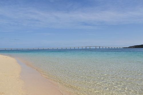
Irabu Ohashi Bridge connects Miyako Island and Irabu Island in Okinawa Prefecture. It opened to traffic on January 31, 2015. The main bridge section is 3,540 meters long and is said to be the longest bridge in Japan that can be crossed free of charge. It links the Tori-ba district of Hirara Port on the Miyako side with the area near Nagayama no Hama on Irabu, and forms part of Okinawa Prefectural Route 252, the Hirara-Shimojishima Airport Line.
The bridge is 8.5 meters wide, its main navigation span is 180 meters, and its clearance above the water is 27 meters. The general sections are prestressed concrete continuous box girders, while the main navigation section, where ships pass, is a steel-deck box girder. A steel arch had originally been planned for the main span, but a wind tunnel test in 2007 revealed a problem with durability, and the design was changed to the current form in 2008. Including the approach roads, the whole route is about 6,500 meters long. Construction began on March 18, 2006. Completion was later than first planned, and the upper structure was joined in September 2014.
Behind the bridge lay a long-held wish of the island's people. The call for a bridge to the outlying island began in 1974 with the then mayor of Irabu Village, and the route was decided in 2000. The 1940 sinking of the ferry Irabu Maru is regarded as the starting point of the effort to build it.
The opening changed daily life considerably. The bus line on Irabu was extended to Miyako Island, while the scheduled ferry service between Sarahama Port and Hirara Port was discontinued on the very day the bridge opened. A water pipe was also built alongside the bridge, carrying water from Miyako's underground dam to Irabu.
Irabu Island lies about 5 kilometers northwest of Miyako Island and is separated from its western neighbor, Shimoji Island, by a narrow inlet. Its highest point is Makiyama in the southeast, 89.0 meters above sea level. In the south of the island is Toguchi no Hama, a long, curving white-sand beach. From the bridge, the view across the Okinawan sea is highly praised. However, stopping or parking ordinary vehicles in the middle of the bridge is prohibited. Many people stop to take photos and accidents have occurred, so enjoy the scenery while driving or from near either end of the bridge.
Sources
This article was written from the official, municipal and tourism-association sources above, and checked against them separately from the writing. Editorial policy
Last updated November 12, 2026