ABOUT
About this spot
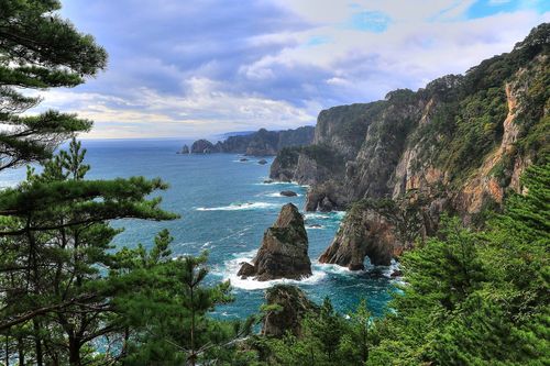
Jodogahama is a coastline on the north side of a peninsula that juts into Miyako Bay in Miyako, Iwate Prefecture. It is designated a national Place of Scenic Beauty and lies within Sanriku Fukko National Park. The view of a blue inlet spreading among white rocks is one of the best-known scenic spots on the Sanriku coast.
Its greatest feature is the group of white rocks standing along the water's edge. They are rhyolite formed in the Paleogene period, thought to be volcanic ash piled on the seabed and later lifted by crustal movement. Evergreens such as the Nanbu red pine take root on top of the rocks, and the contrast of white stone and green is set off by the calm blue water of the inlet. On the open-sea side, rugged scenery carved by heavy waves, with names shared with Osorezan such as Sword Mountain, Sai no Kawara and Pond of Blood, makes a striking contrast with the gentle inner bay.
A widely told story says the name comes from a monk who exclaimed that the place was just like the Pure Land of paradise. The name Jodogahama already appears on a map from the mid-Edo period, so it seems to have been known as a beautiful place for a long time, though the story has no documentary support. In July 1917 Miyazawa Kenji visited and left a poem about the view, and a monument stands nearby.
The base for a walk is the Jodogahama Visitor Center, from which paths lead to the shore. Several viewpoints are nearby, and Odaiba Observatory gives a view of the bay; you can also walk on to neighboring Tako-no-hama. From the sea, the sightseeing boat Miyako Umineko-maru runs a route for viewing the line of rocks. The rest house was badly damaged in the 2011 Great East Japan Earthquake but reopened in July 2012.
In summer the calm inner bay is enjoyed as a beach and has been selected for the Ministry of the Environment's list of Japan's 100 best clean bathing beaches, as well as for the list of Japan's 100 best shores. Spring and autumn are seasons when the clear air shows the white rocks and the color of the sea sharply. Sea conditions and facilities can change, so please check with Miyako city tourism information about boat service before you visit.
Sources
This article was written from the official, municipal and tourism-association sources above, and checked against them separately from the writing. Editorial policy
Last updated October 29, 2026