ABOUT
About this spot
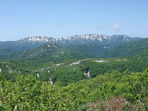
On the Sea of Japan side of the Shirakami Mountains, a World Heritage region in Fukaura, Nishitsugaru District, Aomori Prefecture, a cliff of white rock cuts deep into the green of the beech forest. This scenic spot is called "Nihon Canyon" (Japan Canyon) and lies within Tsugaru Quasi-National Park. Erosion and collapse have exposed the tuff in a huge U-shaped valley, and its white face, clearly visible from far away, is said to serve as a landmark for ships out at sea. The site itself is not included in the Shirakami Mountains World Heritage area.
The origin of the name is well documented. On October 22, 1953 (Showa 28), when Juniko was designated a prefectural natural park, Kishi Mamoru, a national park council member and explorer who was visiting, compared it with the Grand Canyon in America and called it a "baby canyon." In response, the village office of Iwasaki, as it then was, named it "Nihon Canyon." Before that, locals called this mountain "Higurashiyama." The name is said to come from the saying that people were so taken by the beautiful view that they forgot the day was ending; place names such as Higurashi Falls, Higurashi Pond and Higurashi Bridge remain nearby, and the writer Omachi Keigetsu composed poetry about the view.
There are several theories about its formation. In the early Showa period, Arakawa Kenji published a theory that it might be a remnant of a glacier, which was discussed in academic circles at the time. The origin of Juniko as a whole has also not been settled, with explanations ranging from a landslide that dammed the valleys to sinking along a fault combined with erosion of fragile strata.
The entrance to the observation point is the parking lot near Hakkei-no-ike pond in Juniko. You climb a mountain path along a maintained hiking course for about 20 minutes. Wear secure footwear, and take measures against the heat in summer. If you are not confident in your stamina or legs, you can also see the white cliff from National Route 101 at the foot of the mountain or from the Juniko circuit course.
The season matters as well. The Juniko area can be entered from April to November; from December 1 to March 31 the gate is closed and vehicles cannot enter freely. Juniko is a group of 33 lakes and ponds of various sizes, including the Aoike pond and Wakitsubo-no-ike, whose spring water was chosen as one of Aomori Prefecture's famous waters.
For access, Konan Bus runs the Juniko line from Juniko Station on the JR Gono Line. By car, you can use the Oku-Juniko parking lot. From the parking lot to the Nihon Canyon observation point there is a climb on a mountain path, so wear comfortable shoes. Combining it with Aoike and Wakitsubo-no-ike lets you experience the nature of Juniko more deeply.
Sources
This article was written from the official, municipal and tourism-association sources above, and checked against them separately from the writing. Editorial policy
Last updated November 16, 2026