ABOUT
About this spot
Mount Myogi is the collective name for a mountain area spanning Shimonita Town, Tomioka City and Annaka City in Gunma Prefecture, rising at the western edge of the Kanto Plain. It consists of two rows of rocky peaks running from southwest to northeast; across the Nakagi River, the southeastern side is called Omote-Myogi (front Myogi) and the northwestern side Ura-Myogi (back Myogi). With walls of rock and candle-like crags standing in rows, its silhouette is unmistakable even from afar.
Omote-Myogi is divided into three areas: Mount Hakuun (1,104 meters), Mount Kinkei (856 meters) and Mount Kondo (1,094 meters). Of these, Mount Kinkei is currently closed to entry. Myogi Shrine stands on the Mount Hakuun side, and Nakanotake Shrine is on the Kondo side. In Ura-Myogi, Mount Taniyakyu (1,162.1 meters) is the main peak, and rock formations such as Eboshi-iwa and Chosunokashira are well known.
Mount Myogi was designated a Place of Scenic Beauty by the state on 7 March 1923. Together with Yabakei in Kyushu and Kankakei in Shikoku, it is counted as one of Japan's three bizarre scenic spots, and with Mounts Akagi and Haruna it is one of the Joumo Sanzan, the three mountains of Gunma. It was selected among the Hundred Views of Japan and is also on the list of the 200 Famous Mountains of Japan. The area is part of Myogi-Arafune-Saku Kogen Quasi-National Park, and the area around the stone gates is Gunma Prefectural Myogi Park.
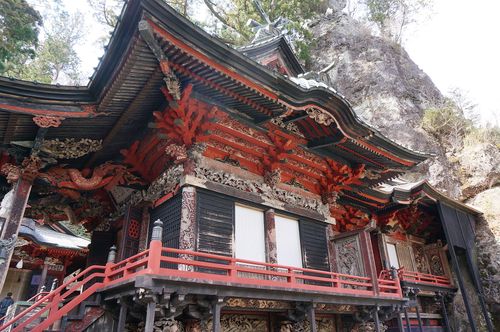
The signature scenery is the group of stone gates, from the first to the fourth, in Omote-Myogi. Besides the gates, strange rock formations such as Taiho-iwa and Hippitsu-iwa are also known. Myogi Shrine is said to have been founded in 537 and stands on the eastern foot of Mount Myogi. The white character "dai" (大) that stands out on the slope of Mount Hakuun comes from the "dai" of Myogi Daigongen, and it once served as a landmark for travelers on the Nakasendo road.
If you only want to look at the rocks, there is Myogi Panorama Park, an area with a 360-degree view of the mountain, which also houses the Tomioka City Myogi Visitor Center providing sightseeing and hiking information. The "Chukan-michi" path linking Myogi Shrine and Nakanotake Shrine is designated as part of the Kanto Fureai no Michi trails for general hikers. At the foot of the mountain is Michi-no-Eki Myogi, opened in 2000.
The seasons bring cherry blossoms and fresh greenery in spring and autumn foliage in fall. Prefectural Route 196 is called the "Myogi Momiji Line." There is also Lake Myogi, formed by the Nakagi Dam on the Nakagi River.
That said, this is a demanding mountain to climb. Rocky ridges continue one after another, the traverse route has chain sections such as Takamodoshi, Horikiri and Oku-no-in, and falls are reported almost every year. Visitors are also warned about mountain leeches. If you plan to hike, check official guidance from Tomioka City and others in advance for closed trails and restricted areas, and enjoy the mountain within your abilities.
Sources
This article was written from the official, municipal and tourism-association sources above, and checked against them separately from the writing. Editorial policy
Last updated November 12, 2026